Chapter: 03. Major Landforms Of The Earth
Major Landforms of the Earth
Understanding Landforms
A landform is a natural or human-made feature found on the solid surface of the Earth. When many landforms are grouped together, they create a terrain, and the way they are arranged in a landscape is called topography.
Land covers about 29% of the Earth’s surface, but it looks different everywhere. Some areas are flat and low, while others are hilly or mountainous. The different shapes of the Earth’s surface are very important for life. Flat, low areas are great for farming. Hill slopes are suitable for growing vineyards and orchards. How Landforms are Created
Landforms are shaped by two main types of processes:
Internal Processes (Endogenous): These processes happen inside the Earth. They cause parts of the Earth’s surface to move upwards (upliftment) or downwards (sinking). These movements lead to the formation of folds and faults in the Earth’s crust. External Processes (Exogenous): These processes continuously wear down and rebuild land surfaces. Erosion: The wearing away of the Earth’s surface. Deposition: The rebuilding of a surface that has been worn down. These processes are carried out by natural agents like running water, ice, and wind, as well as by the atmosphere and even humans. Earth’s Ancient Past
Millions of years ago, all the land on Earth was joined together in one huge landmass called Pangaea. Over time, this supercontinent broke apart.
Did You Know? Plate Tectonics
Plate Tectonics is a scientific theory explaining that the Earth’s outer layer, called the crust, is broken into several large pieces, or plates. These plates slowly move or “glide” over the semi-solid layer beneath them, known as the mantle. The movement of these plates can cause big events like:
The formation of mountains
Continents
Continents are very large landmasses surrounded by vast water bodies called oceans. They are the main divisions of land on Earth. There are seven continents in the world.
The continents and oceans of the world
A A pie chart showing the percentage of the earth’s land area occupied by the different continents Here’s a closer look at each continent:
Largest continent, occupying about one-third of the planet’s land area. Joined to Europe, forming the combined landmass called Eurasia. Separated from Europe by the Ural Mountains, Black Sea, and Caspian Sea. Surrounded by oceans on three sides: Arctic Ocean (north), Pacific Ocean (east), and Indian Ocean (south). Second largest continent after Asia. Surrounded by water bodies on all sides. Mediterranean Sea separates it from Europe in the north. Indian Ocean to its east. Atlantic Ocean to its west (separating it from the Americas). Home to the world’s largest hot desert, the Sahara Desert. Third largest continent in size. Connected to South America by a narrow strip of land called the Isthmus of Panama. Atlantic Ocean lies to its east and the Pacific Ocean to its west. Fourth largest continent. Shaped roughly like an inverted triangle. Atlantic Ocean on its east and the Pacific Ocean on its west. A large, frozen landmass located in the extreme south. Most bleak and barren part of the world, almost circular in shape. Contains 90% of the world’s ice. Colder than the Arctic region and surrounded by stormy seas. Many countries have research stations here for studies in climatology, earth sciences, human physiology, and medicine. Smaller in size compared to other continents but has many developed nations. Arctic Ocean to its north. Atlantic Ocean separates it from North America. Has the most indented (jagged) coastline among continents, leading to numerous ports and excellent harbours. Sometimes called ‘the Land Down Under’ because it lies south of the main landmasses. Smallest continent in size. Completely surrounded by water (Indian Ocean in west, South Pacific Ocean in east, Southern Ocean in south, Arafura Sea in north), making it an island continent.
Major Landforms
Here, we will explore the most common and prominent landforms found on Earth.
A Some major landforms Mountains
Mountains are huge areas of the Earth’s crust that rise significantly above their surroundings. They can have steep or gentle slopes and often appear in long, narrow lines called ranges.
Formation of Mountains
Mountains are formed when two large pieces of the Earth’s crust, called tectonic plates, crash into each other beneath the surface.
This collision pushes the plates upwards, creating high peaks. Sometimes, a heavier plate is forced to slide under a lighter plate in a process called subduction. These movements inside the Earth are responsible for forming mountains and volcanoes, and this process is called endogenous (meaning “coming from inside”). Types of Mountains
There are three main types of mountains:
Fold Mountains
Fold mountains are formed when layers of the Earth’s crust are squeezed and folded by powerful forces from inside the Earth (compression).
A Layers of the earth’s crust
A Compression of the crust leads to the formation of fold mountains. There are two types of fold mountains:
Formed over 250 million years ago. Examples: Urals in Russia, Appalachians in North America, Aravallis in India. Characteristics: Gentle slopes and low altitude due to being worn down by weathering over a very long time. Formed more recently, about 25 million years ago. Include the world’s highest mountain ranges. Examples: Rockies of North America, Andes of South America, Alps of Europe, Great Dividing Range in Australia, Atlas Mountains in Africa, Himalayas of Asia. Characteristics: Rugged (rough) and lofty (very high).
A Mountains are the highest areas on the surface of the earth.
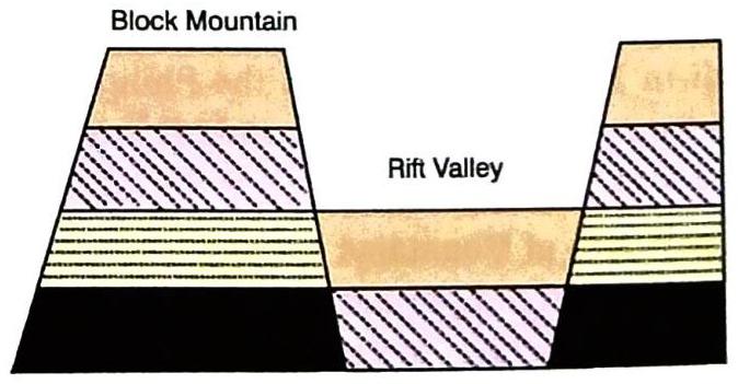
Block Mountains
Block mountains are formed because of faulting. Faulting is when rock layers (strata) in the Earth’s crust break or fracture due to stress.
When these cracks or faults happen, the land between the cracks sinks downwards. This leaves behind tall, standing blocks of land on either side of the sunken area, which are called block mountains. Characteristics: The edges of block mountains are steep, and their surfaces are usually almost level. Examples: The Vosges and the Black Forest in Europe, and the Vindhyas in India.
A How block mountains are formed
Difference between Fold Mountains and Block MountainsFeatureFold MountainsBlock MountainsFormationFormed when layers of Earth’s crust are folded by compression.Formed due to faulting (fracturing of rock strata due to strain).AppearanceCan be rugged and lofty (young) or gentle (old).Have steep edges and almost level surfaces.ProcessCompression.Rupturing/Fracturing and sinking of land blocks. Volcanic Mountains
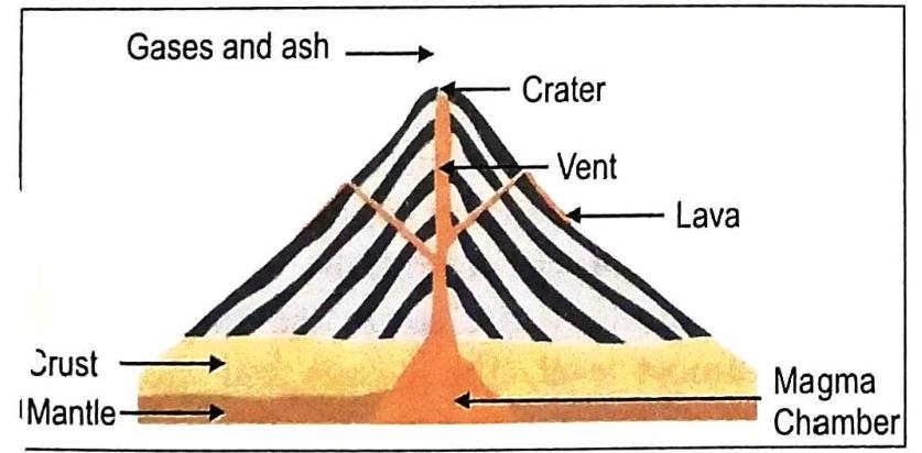
You might have heard about the destruction caused by volcanic eruptions from mountains like Mt. Krakatoa, Mt. Vesuvius, and Mt. Pelée. These are all examples of volcanic mountains.
Formation: Volcanic mountains are built when molten rock (lava), ash, cinder, and dust from deep inside the Earth erupt onto the surface through cracks in the Earth’s crust. These materials then pile up to form high cone-shaped mountains. Vent: The opening through which lava and other materials escape to the surface. Crater: The funnel-shaped dip or bowl at the very top of a vent.
A A volcanic mountain and its parts Examples: Mt. Fuji in Japan, Mt. Mayon in the Philippines, Mt. Kilimanjaro in Tanzania, and Mt. Vesuvius and Mt. Etna in Italy.
Importance of Mountains
Mountains are extremely important for many reasons:
Water Storehouse: They are a natural storage place for water. Many rivers begin in glaciers (large ice masses) found in mountains. Water Usage: Water from mountains is used to fill reservoirs, which then provides water for irrigation (watering crops) and generating hydroelectricity (electricity from water power). Farming: River valleys and terraces in mountains are very fertile and suitable for farming and growing crops. Biodiversity: Mountains are home to a wide variety of plants (flora) and animals (fauna). Climate Regulation: Mountains affect the climate of an area. For example: The Himalayas block the south-west monsoon winds, causing rainfall in India. They also protect India from the cold winds blowing from Central Asia during winter. Mineral Resources: Mountains are rich in deposits of minerals and metals, which are vital for industries. Human Habitation: According to the United Nations Development Programme (UNDP), about 720 million people live in mountainous regions. Forest Products: Forests in mountainous areas provide essential resources like fuel, fodder (animal food), shelter, and other products such as gum, wild fruits, mushrooms, and resins. Tourism and Recreation: Mountains are popular holiday spots for tourists who enjoy their natural beauty and relaxation. Sports: Many recreation, sporting, and tourism activities take place in mountains, including paragliding, hang gliding, river rafting, and skiing.
Plateaux
Plateaux (plural of plateau) are elevated sections of the Earth’s crust that are mostly flat or level on top, but usually drop steeply down to the surrounding lower lands. They are sometimes called “plains-in-the-air” or “tablelands” because of their flat tops.
Examples: The Plateau of Tibet in Asia, the East African Plateau in Africa, and the Colorado Plateau in North America. In India: The Deccan Plateau (large and fertile) and the Chota Nagpur Plateau (rich in minerals). Economic Value: Plateaux are very important for their mineral wealth. South African Plateau: Yields gold, diamond, copper, manganese, and chromium. Western Australia: Rich in gold and iron.
A map showing major mountains and plateaux Types of Plateaux
Plateaus are classified based on how they formed, their appearance, and their location:
Formed by the movement of the Earth’s crustal plates. Tectonic movement causes a large part of the Earth’s surface to rise. Examples: South African Plateau and the Turkish-Iranian Plateau. Formed by layers of molten lava spreading over a region. When the lava cools and hardens, successive layers build up over time to form a raised tableland or plateau. Examples: Extensive Columbia Plateau (north-western USA), north-western part of the Deccan Plateau, and the Malwa Plateau in India. Have an uneven surface marked by canyons, gorges, and steep, narrow valleys. These features are formed by the process of erosion. Common in dry and desert regions. Examples: The Colorado Plateau (through which the Grand Canyon passes) and the Brazilian Plateau (Mato Grosso). These plateaus are surrounded by mountains on all sides. They are the most common type of plateau. Example: The Tibetan Plateau, which is enclosed by the Himalayan Mountains to its south and the Kunlun Shan to its north. A plateau that lies between a mountain and a plain or an ocean. Examples: The Patagonia Plateau in South America and the Piedmont Plateau of North America.
Basins
A basin is a sunken or depressed area of the Earth’s crust that is surrounded by higher land.
Many basins are found next to plateau edges. They often form areas of inland drainage, meaning the rivers flowing into the basin do not reach the sea. Examples of basins with inland drainage: The Tarim and Tsaidam Basins in Asia, and the Chad Basin in north-central Africa.
Valleys
Valleys are low-lying areas of land found between hills or mountains. They can be formed in two main ways:
By exogenous (from the outside) processes, such as a river flowing down from mountains and eroding the land. Due to the movement of plates inside the Earth. Types of Valleys
A type of valley formed when the land between two faults (breaks in the Earth’s crust) sinks downwards. Essentially, a rift valley is the land located between two block mountains. Examples: The Narmada Valley in India and the Nile Valley in Egypt. These valleys usually have a river flowing through them. They are typically V-shaped. Examples: The Rhine Valley in Europe and the Damodar Valley in India. Valleys may or may not have a river flowing through them. Quick Facts: Glacial Valleys
Valleys formed by glaciers (large, slow-moving rivers of ice) are typically U-shaped. Many such U-shaped valleys are found in the Alps and the Himalayas.
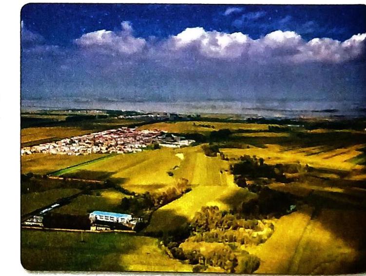
Plains
Plains, also known as lowlands, are vast, mostly flat areas of land. They are usually less than 200 metres above sea level.
Formation: Most plains are built by alluvium (fine-grained soil and sediment) deposited by large rivers and their smaller streams (tributaries). Because of this, they are often called river plains. Characteristics: River plains are very fertile. Their flat nature makes it easy to build roads and railways.
A Alluvial plains are rich and fertile. Types of Plains
Plains are grouped into three categories based on how they are formed:
Located near the coast of a sea or ocean. Mainly formed by the uplift (rising) of a part of the seafloor or continental shelf due to internal Earth movements. Large, broad, and flat areas of the seafloor are raised to the surface. Sediments brought by sea waves over time make them even broader and flatter. Examples: Coastal plains of south-eastern USA near the Gulf Coast (part of the Great Plains, one of the largest plains), plains of northern Russia, and central lowlands of Australia. Result from the erosion (wearing away) of mountains, hills, and plateaux. The eroded material is carried down to a low level by natural agents like wind, rivers, rain, and glaciers. This erosion creates various types of plains. Examples: Plains of northern Canada, northern Europe, and Kashmir in India. Peneplain: A level land surface created by erosion over a very long period, without being disturbed by crustal movements. Formed by sediments brought down on a large scale by natural agents (moving ice, water, wind) from higher mountainous regions. Coastal plains are a type of depositional plain found along the edges of continents next to seas (e.g., eastern and western coastal plains of India).
A map showing the distribution of major plains in the world Importance of Plains
Plains are incredibly important for human life:
Ideal for Life: Of all landforms, plains are the most suitable for both humans and animals. High Population: Plains have always supported large populations, like the Indo-Gangetic Plain, the Mississippi Plain, and the Yangtze Plain. Agriculture: Crops like rice, wheat, and sugarcane are widely grown in plains, making them the “granaries of the world.” Urbanization & Industry: Large cities and towns are mostly located in plains. The opportunities for industrial development are much greater here than in other terrains. Easy Construction: The soft and flat surface of plains makes it easy to build roads, railway tracks, and airports.
Minor Landforms
Beyond the major landforms, there are also smaller, but equally interesting, features on the Earth’s surface.
Islands
An island is a piece of land that is completely surrounded by water on all sides.
Examples in India: The Lakshadweep Islands in the Arabian Sea and the Andaman and Nicobar Islands in the Bay of Bengal. Other examples: Sri Lanka (south of India, in the Indian Ocean), Madagascar (another big island in the Indian Ocean). Peninsulas
A peninsula is a piece of land that is surrounded by water on three sides and is connected to a larger landmass on the fourth side.
Examples: The peninsular plateau of India and the Malay Peninsula are both attached to the continent of Asia. Europe itself is sometimes described as a “peninsula of peninsulas” due to its many smaller peninsulas jutting out into the surrounding water bodies (Atlantic Ocean, Arctic Ocean, Mediterranean Sea).
A The peninsular plateau of India and the Malay Peninsula-two peninsulas in the Indian Ocean and Sri Lanka, an island off the coast of India Isthmuses
An isthmus is a long, narrow strip of land that has water on both sides and connects two larger landmasses.
The Isthmus of Panama joins North America and South America, with the Pacific Ocean on one side and the Atlantic Ocean on the other. The Isthmus of Suez joins Africa to Asia and separates the Mediterranean Sea and the Red Sea.
A The Isthmus of Panama
Landforms and People
Landforms significantly impact human life in many ways:
Natural Disasters: Events like earthquakes or volcanic eruptions can cause severe loss of human life and property. Safety & Dwelling: The type of rocks and soil a landform is made of determines if humans can safely live there. Weather & Climate: Landforms influence weather. Generally, the higher you go (like in mountains), the colder it gets, while plains and valleys tend to be warmer. Since landforms affect climate, they also affect farming. It’s harder to grow crops and raise cattle on hillsides than in flat plains. Ease of Living: In plains, it’s easier for people to build roads, houses, and dig wells. Life in mountainous regions is often more challenging than life in the plains. Sustainable Development Goals (SDGs): Goal 15: Life on Land
Conserving landforms is crucial for:
Maintaining the balance of nature (ecological balance). Protecting the variety of life (biodiversity). Ensuring natural resources can be used sustainably over time. It’s important to set up and protect special areas to safeguard unique and delicate landforms. These protected areas can also help promote landform conservation.
Influence of India’s Geographical Features on Shaping Its History
India is so large that it’s often referred to, along with its neighbouring countries, as the subcontinent. India’s geography has played a huge role in shaping its history:
Acts as a natural barrier, protecting the country from invaders coming from across the border. Mountain Passes (North-West): Served as important trade routes. Allowed many groups, such as the Central Asians, to enter the country for trade and cultural exchange. Many seafaring nations used the sea routes along India’s long coastline for trade and interaction. Rivers and Fertile Plains: India is a land of many rivers (like the Ganga, Indus, Narmada). People preferred to live near these rivers because the water made the plains very fertile, providing great opportunities for settled life. This is why ancient civilizations flourished in these river valleys.  Self Study
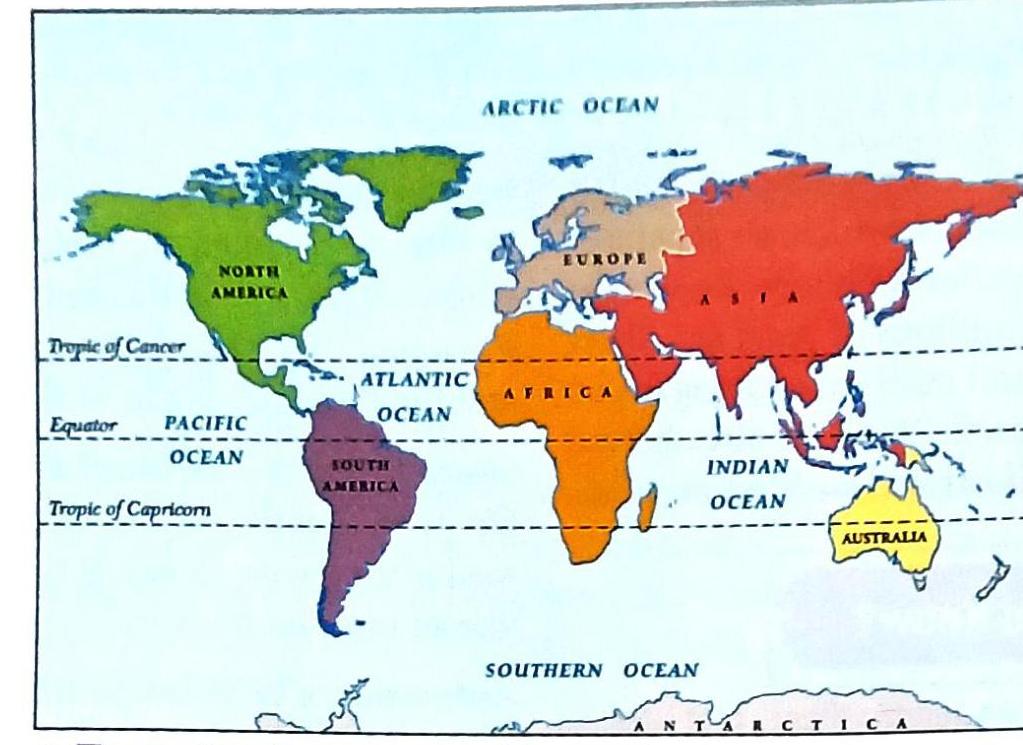
The continents and oceans of the world
The continents and oceans of the world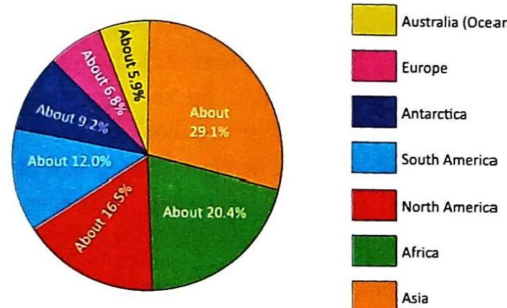
A A pie chart showing the percentage of the earth’s land area occupied by the different continents
A A pie chart showing the percentage of the earth’s land area occupied by the different continents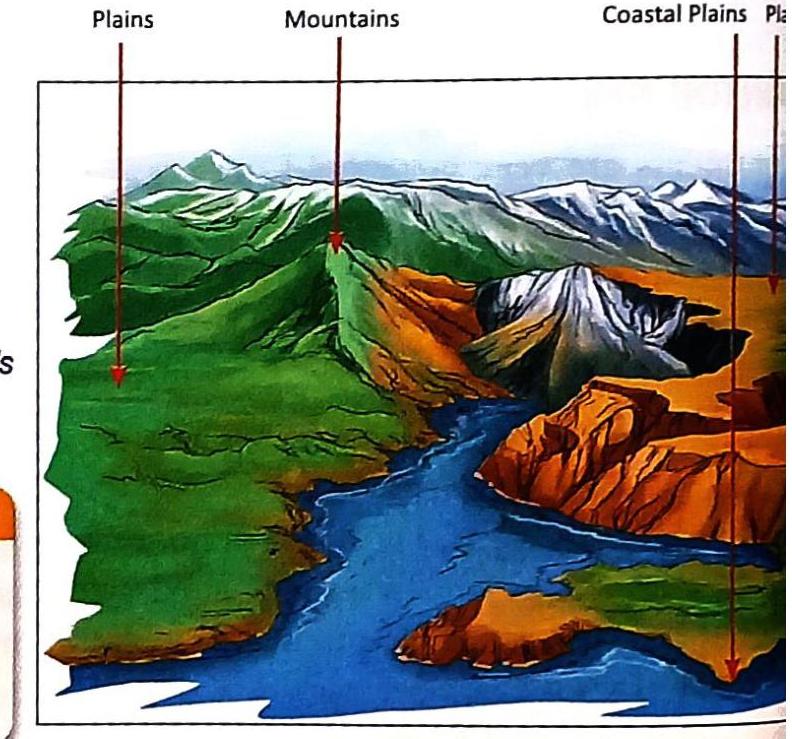
A Some major landforms
A Some major landforms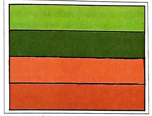
A Layers of the earth’s crust
A Layers of the earth’s crust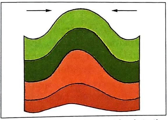
A Compression of the crust leads to the formation of fold mountains.
A Compression of the crust leads to the formation of fold mountains.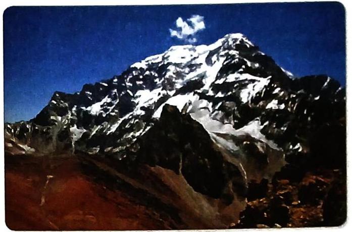
A Mountains are the highest areas on the surface of the earth.
A Mountains are the highest areas on the surface of the earth.

A How block mountains are formed
A How block mountains are formed


A A volcanic mountain and its parts
A A volcanic mountain and its parts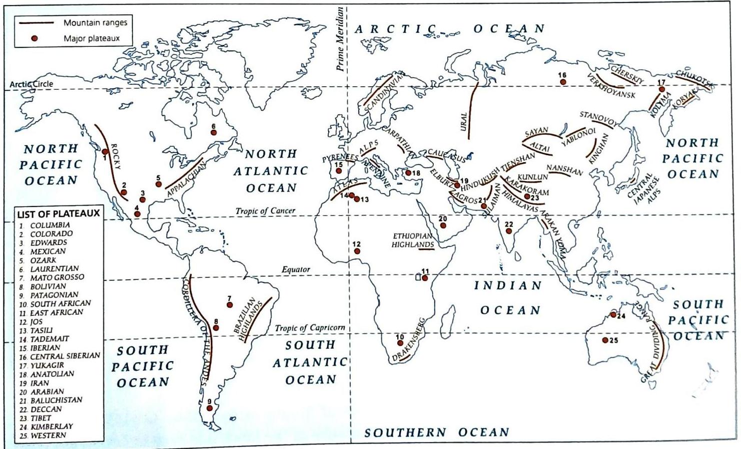
A map showing major mountains and plateaux
A map showing major mountains and plateaux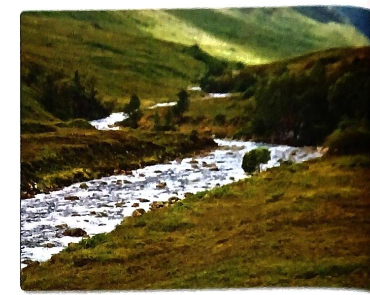
A valley
A valley
A Alluvial plains are rich and fertile.
A Alluvial plains are rich and fertile.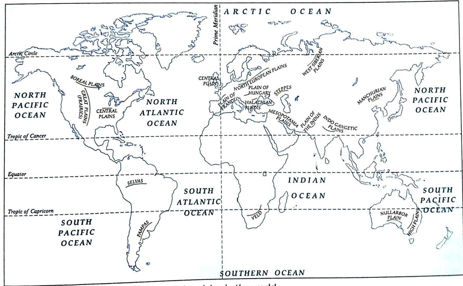
A map showing the distribution of major plains in the world
A map showing the distribution of major plains in the world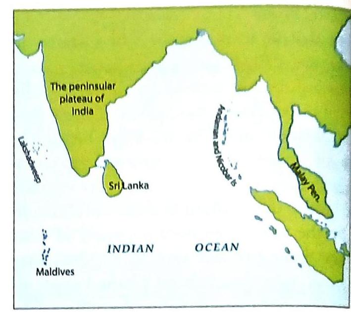
A The peninsular plateau of India and the Malay Peninsula-two peninsulas in the Indian Ocean and Sri Lanka, an island off the coast of India
A The peninsular plateau of India and the Malay Peninsula-two peninsulas in the Indian Ocean and Sri Lanka, an island off the coast of India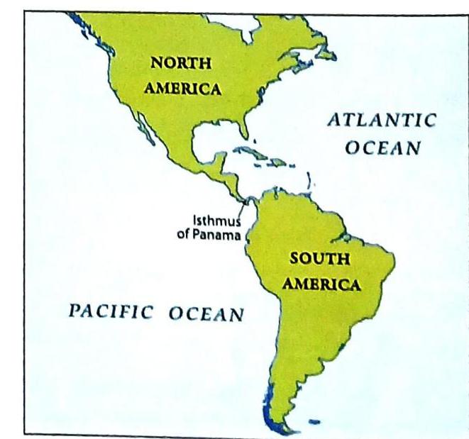
A The Isthmus of Panama
A The Isthmus of Panama