Chapter: 09. South America
THEME 6: STUDY OF CONTINENTS-NORTH AND SOUTH AMERICA
9. South America
Learning Outcomes
Upon completing this study, you will be able to:
Locate South America on a world map and in an atlas. Identify and mark different countries in South America on their respective maps. Locate and identify the physical features of South America on the map. Understand and compare life in lumbering regions (like Canada) with life in the Amazon Basin. Describe how the geography of a place influences the life of its people through specific examples.
Introduction and Location
South America is the fourth largest continent globally. It is connected to North America by a narrow land strip known as the Isthmus of Panama. Apart from this narrow connection, the continent is surrounded by water on all other sides. While most of South America lies in the Southern Hemisphere, a portion of it extends north of the equator. Its shape is triangular, being wider in the north and narrowing down to a point at Cape Horn in the south.
South America is situated in the Western Hemisphere, with a significant part south of the equator, reaching as far as the Southern Ocean. Its geographical coordinates stretch from 12° N to 55° S latitude and from 35° W to 81° W longitude. The Pacific Ocean borders the continent to the west, and the Atlantic Ocean to the east. The Caribbean Sea lies directly north of South America.
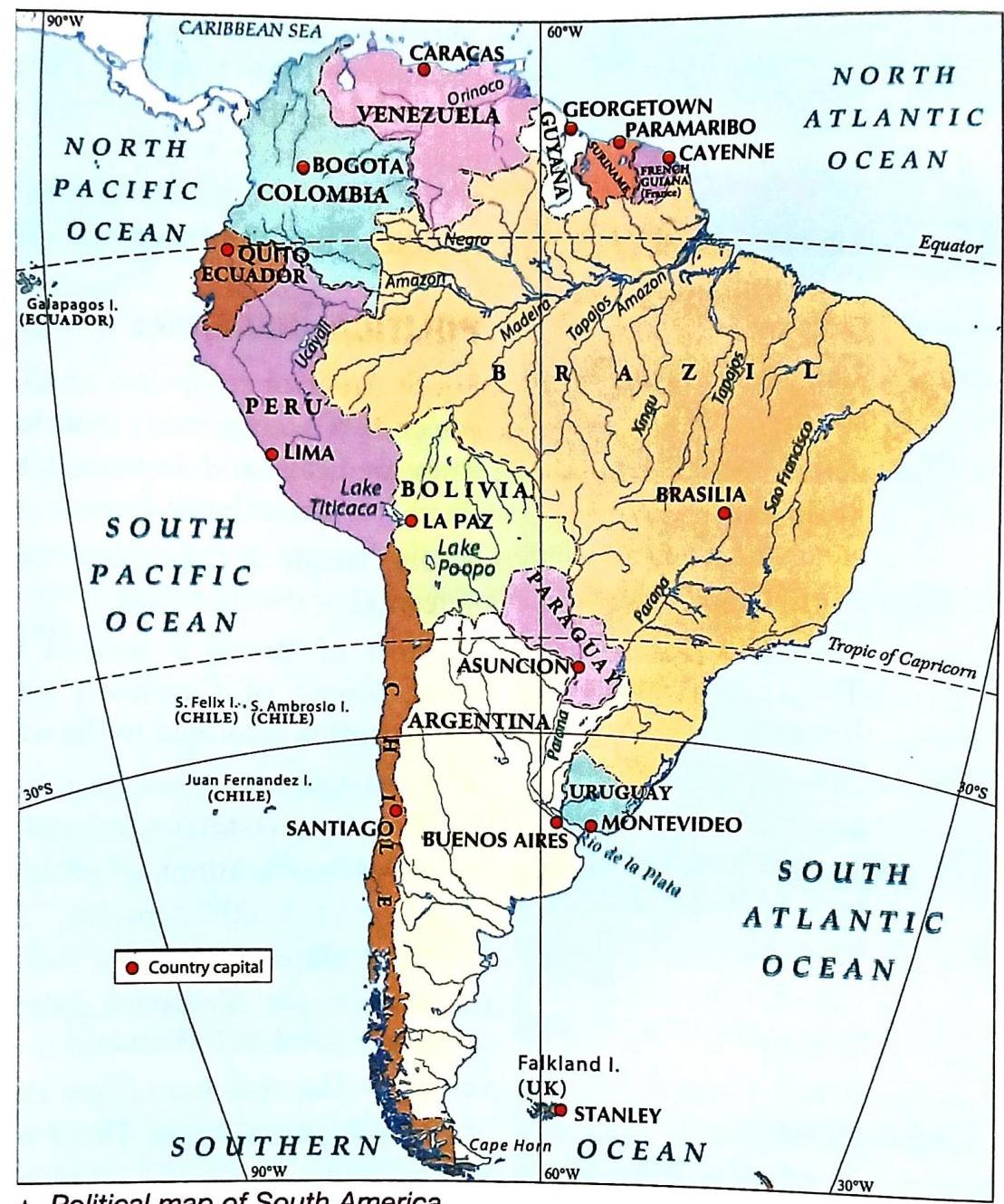
A Location of South America Most of South America lies between the equator and the Tropic of Capricorn, which passes just south of Rio de Janeiro. The equator crosses near the mouth of the Amazon River. The 60° W longitude passes almost through the middle of the continent.
Did You Know?
La Paz, a city in South America, boasts the world’s largest urban cable car system, named Mi Teleférico. This system features 11 lines connecting various parts of the city, offering stunning views of the Andes mountains and valleys. It is not only an affordable and eco-friendly mode of transport but has also helped reduce traffic congestion and air pollution.
South America at a glance
Political Divisions
South America is composed of 13 countries. Among them, Brazil and Argentina are the largest, together occupying more than half of the continent’s area, and both are located along the Atlantic Ocean.
The Tropic of Capricorn roughly divides the continent through its center. Most of Brazil is situated north of the Tropic of Capricorn, while most of Argentina lies to its south. Peru, Colombia, and Bolivia are other large countries in South America. A number of islands are located off the coast: Galápagos Islands: An archipelago of volcanic islands belonging to Ecuador. Juan Fernandez Islands: Located west of Chile in the South Pacific Ocean. Falkland Islands (also called Malvinas) and South Sandwich Islands: These are British overseas territories. The Falklands have internal self-governance, but the South Sandwich Islands have no permanent population. Tierra Del Fuego, which includes the southern tip of Cape Horn, is separated from the mainland by the Strait of Magellan. The two primary languages spoken in South America are Spanish and Portuguese.
Countries of South America
Quick Facts
South America, Central America, Mexico, and the West Indies are often collectively referred to as Latin America. This term is used because the first people to settle in these lands were primarily Latin-speaking races from southern Europe.
Physical Features
The continent of South America is characterized by four primary physical divisions:
The Andes Mountains/Western Mountains The Eastern Highlands
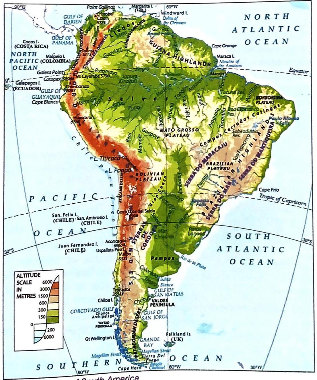
A Physical map of South America The West Coastal Plains
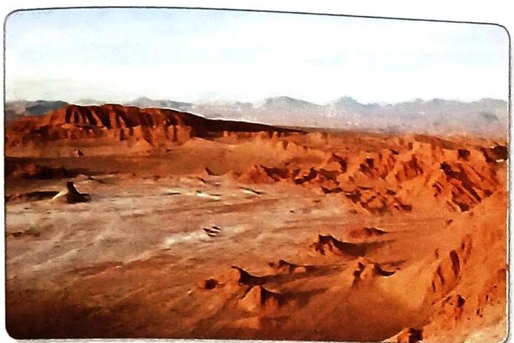
This is a very narrow plain situated between the Andes Mountains and the Pacific Ocean, along the western side of the continent. It stretches along the entire length of the continent, with varying widths. In Peru, it is at its widest, reaching 80 km. Elsewhere, its width typically ranges from 10 to 15 km. The hot Atacama Desert, known as the driest desert in the world, lies within this coastal region across the Tropic of Capricorn in northern Chile.
Δ The Atacama desert The Andes Mountains
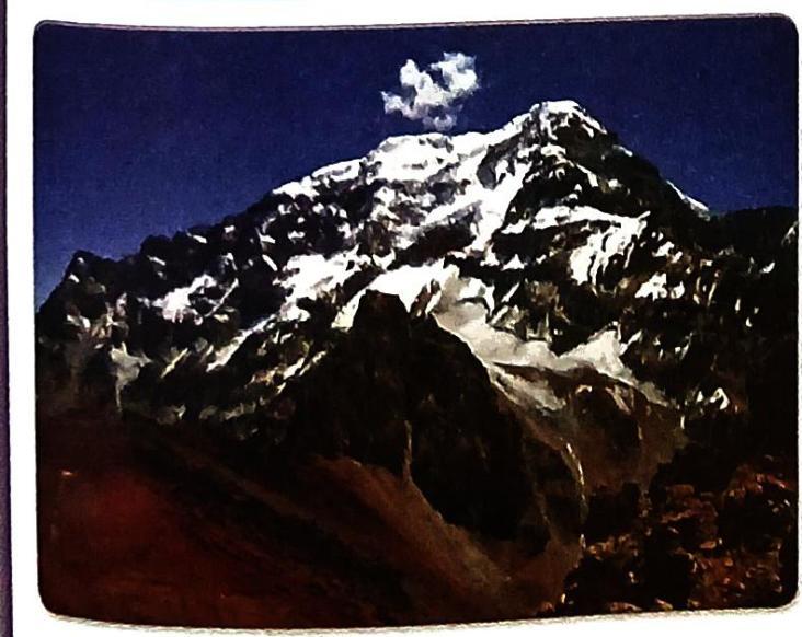
Also known as the Western Mountains, the Andes Mountains are a long stretch of high, young fold mountains. They run parallel to the Pacific Coast in the western part of South America.
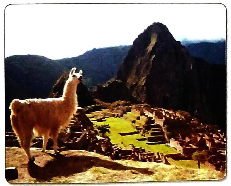
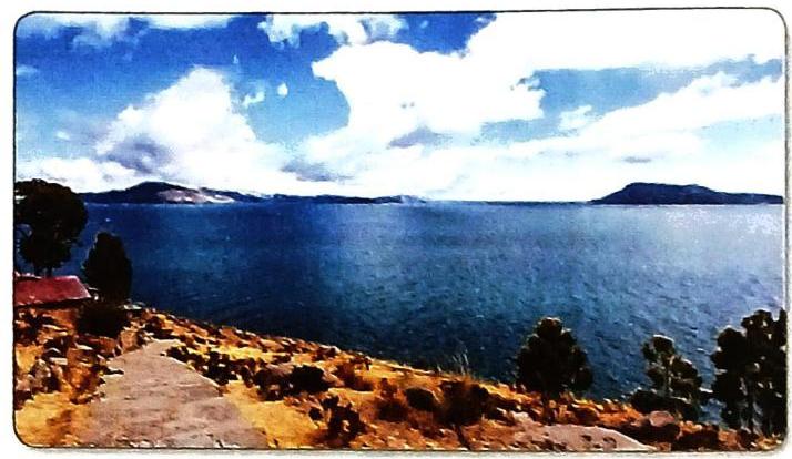
Δ The Andes mountains It is the second highest mountain range in the world. The Andes are not a single range but comprise several parallel ranges with basins and plateaus in between. In Spanish, this mountain range is often referred to as the Andean Cordilleras. The Andes contain numerous lofty peaks, with the highest being Mt Aconcagua (6,960 m). Some high peaks remain snow-covered even near the equator. Due to their immense height, these mountains are very challenging to cross. The Uspallata Pass is one of the few gaps or breaks in this towering mountain chain. Lake Titicaca, the second highest freshwater lake globally, is found here.
Δ Titicaca Lake, near Puno, Peru The Andes also have many active volcanoes, alongside some dormant and extinct ones. Notable active volcanoes include Mt Chimborazo (6,310 m), Mt Cotopaxi (5,896 m, the highest active volcano in the world), and Mt Cayambe (5,790 m), all located in Ecuador. The Central Plains
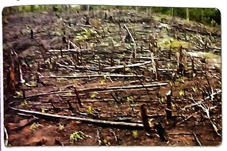
This region of lowlands is located in the center of the continent, nestled between the Andes in the west and the Eastern Highlands. These flat plains are formed by the depositions of major rivers: the Amazon, Orinoco, Parana, Paraguay, and Uruguay. The Parana, Paraguay, and Uruguay rivers collectively form the La Plata river system. In the north, the Orinoco Plains are called the llanosc, which means ‘plains’ in Spanish. The Orinoco River originates in the Guiana Highlands and flows into the Atlantic Ocean. It is a navigable river. South of the llanos, the Amazon Lowlands are known as the selvas, a region characterized by dense equatorial forests.
Deforestation in the Selvas The Amazon River is the second longest river globally, after the Nile. It has numerous tributaries. This vast river system begins in the Andes Mountains of Peru and flows through Ecuador, Colombia, Venezuela, Bolivia, and Brazil before discharging into the Atlantic Ocean. Further south is the La Plata Basin, drained by the Parana, Paraguay, and Uruguay rivers. These rivers converge and flow into the Rio De la Plata estuary, which empties into the Atlantic Ocean. The temperate grassy plains of Argentina are called the pampas. The Parana-Paraguay Lowlands include the Gran Chaco, a vast alluvial region that is poorly drained and often becomes marshy during the rainy season. The Eastern Highlands
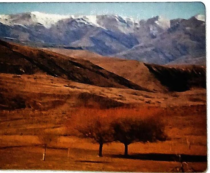
The Guiana Highlands and the Brazilian Highlands constitute the Eastern Highlands. These two highland regions are separated by the Amazon River. They extend across the eastern part of the continent, running along the Atlantic coast. The Eastern Highlands rise steeply from the Atlantic Coast in the east but have gentler slopes in the west, where they gradually descend towards the Central Plains. Their height is significantly lower compared to the Andes. Unlike the young fold Andean mountains, the Eastern Highlands are composed of old, hard rocks. The world’s highest waterfall, Angel Falls, is formed in the Guiana Highlands. In Argentina, between 40° S and 50° S, lies a cold desert known as the Patagonian Desert.
Δ The Patagonian Desert Did You Know?
While most South American countries have Spanish as their official language, Brazil’s official language is Portuguese. This distinction arises because Brazil was a colony of Portugal, whereas most other South American countries were colonies of Spain.
Physical features of South America (Comparison Table)
Rivers and Lakes
South America is home to several significant river systems and a few notable lakes.
The Orinoco River, which is 2,400 km long, originates in the Guiana Highlands and flows towards the Atlantic Ocean in Venezuela. The Angel Falls (979 m), the world’s highest waterfall, is formed by a tributary of the Orinoco River. The Magdalena River in Colombia runs parallel to the Andes Mountains and drains northwards into the Caribbean Sea. The Amazon River, measuring 6,400 km in length, rises in the Andes Mountains and flows eastwards across the widest part of the continent. It is fed by thousands of tributaries and daily heavy equatorial showers, making it the river that carries the largest volume of water in the world. The Amazon is navigable by ocean-going liners up to Manaus.
The La Plata River system is formed by the Paraguay, Parana, and Uruguay rivers. These rivers flow southwards and drain into the South Atlantic Ocean through a wide estuary in Argentina, which serves as an excellent harbor. South America has only a few lakes: Lake Titicaca is situated on the high plateau of Bolivia. It is drained by the Desaguadero River into Lake Poopo. Lake Poopo is a saltwater lake and an area of inland drainage. Lake Maracaibo in Venezuela is highly significant due to its rich mineral oil deposits.
CASE STUDY: LIFE IN THE AMAZON BASIN
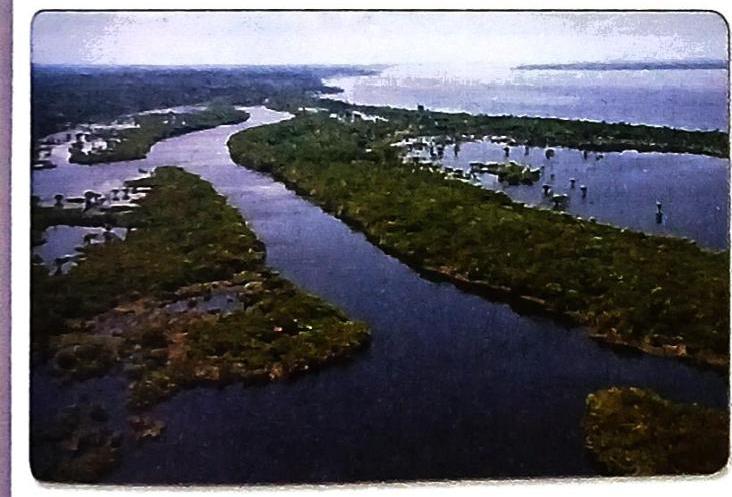
The Amazon Basin, drained by the Amazon River, is primarily covered by equatorial forests. These forests are called ‘equatorial forests’ because the river basin spans across the equator.
Climate: The climate is hot, wet, and humid, with rainfall occurring almost every day. Rainforest: The Amazon Basin is the largest rainforest in the world. The Amazon River serves as the basin’s main waterway and is the largest river globally by the volume of water it discharges into the ocean. The Amazon Basin plays a crucial role in global climate and the water cycle. Biodiversity: The Amazon forest is a home to millions of species: 2.5 million different insect species Natural Resources: The Amazon rainforest is a rich source of natural resources, including timber, rubber, nuts, fruits, medicinal plants, and minerals. Population: Approximately 2 to 3 million people live in the Amazon Basin.
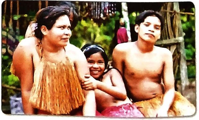
Δ Amazon tribals Indigenous People’s Lifestyle: Traditionally, they were hunter-gatherers leading a nomadic life. They did not stay in one place for long, cultivating crops after cutting down and burning trees (shifting cultivation). They engaged in hunting and fishing. Over the last 500 years, many have had contact with outsiders, leading to a large number of people now living in towns and cities. Transportation: Boats are their cheapest and most convenient means of travel due to the absence of roads. Hunting: They hunt birds, fish, and animals like crocodiles and turtles found near the river. Historically, they used blowpipes, poison-tipped arrows, and spears for hunting and warfare, but today they live peacefully. Settlements: Most people in the Amazon River Basin live in settled villages along the rivers. Reliance on Forest: They depend on the forests for food, shelter, tools, and medicine. Agriculture: They grow vegetables and fruits such as bananas, tapioca, pineapple, and sweet potato. Cash crops like coffee, maize, and cocoa are also cultivated. Sustainability: They live sustainably in the forest, taking care of its resources. Languages: More than 180 languages are spoken by different tribes in the region. Livelihood: They earn a living from tourism or by supplying locally-grown vegetables to markets. Threats to Traditional Life and Rainforest: The traditional way of life of indigenous people is under threat. They are losing their traditional territory due to illegal logging, oil and gas exploration, and the rapid spread of ranching and farming. Increased access for outsiders has forced indigenous populations to settle in new areas, contributing to the gradual destruction of the rainforest. However, these forest-dwelling people are now actively working to protect their culture, the forest, and the diversity of plant and animal life they rely upon. Sustainable Development Goals (SDGs) - Goal-13: Climate Action
The Amazon rainforest absorbs one-fourth of the carbon dioxide absorbed by the entire Earth’s surface. However, the amount absorbed now is about one-third less than in the 1990s, mainly due to large-scale deforestation. A primary cause of deforestation is cattle ranching, undertaken to supply meat to countries like China, the United States, and Europe.
Brazil has shown success in reducing its impact on climate change. In the past two decades, its carbon dioxide emissions (a major cause of global warming) have decreased more than any other country. The destruction of the rainforest in Brazil dropped significantly, from about 20,000 sq. km. per year in the late 1990s to about 5,000 sq. km. per year in 2022. The ongoing challenge is to stop illegal deforestation.
Values and Life Skills - Concern for Justice and Equality
It is important to use natural resources responsibly without harming the environment. The indigenous people in the Amazon Basin serve as an excellent example of this principle. Living sustainably means:
Using resources efficiently. Supporting practices that protect the environment and future generations.
Biography
Amerigo Vespucci was a 16th-century Italian merchant and explorer. The continents of North and South America are named after him. The German cartographer, Martin Waldseemüller, was the first to propose naming the newly discovered lands after Vespucci in a map published in 1507. Vespucci’s letters and reports about his voyages to the “New World” were widely circulated in Europe. His accounts were instrumental in popularizing the idea that Christopher Columbus had not reached Asia but had, in fact, discovered an entirely new continent.
Important Terms
Llanos: The grasslands of the Orinoco Basin. Selvas: The dense equatorial forest of the Amazon Basin. Pampas: The extensive temperate grasslands of Argentina. Archipelago: A group of islands.
Climate of South America
A significant portion of South America lies within the tropical zone, resulting in generally hot temperatures. The climate is influenced by several factors:
The presence of the Andes Mountains. The height of a place above sea level (altitude). Proximity to seas and oceans. Impact of ocean currents (e.g., warm Brazilian Current and cold Peru Current). Since most of South America is in the Southern Hemisphere, a large part experiences summer in December and early January, and winter in June-July.
January Climate (Summer in South): Hottest areas are southern Brazil and northern Argentina, as the sun is overhead the Tropic of Capricorn. Average temperatures exceed 27° C. Heavy summer rainfall occurs over most of South America. The Northeast and Southeast Trade Winds bring heavy rain to the Guiana Highlands and Brazil. The northern and central Andes block these Trade Winds, preventing rain from reaching regions west of the Andes, making them very dry and hot (e.g., Atacama Desert). Equatorial regions receive heavy, convectional rains throughout the year. July Climate (Winter in South): When the sun is directly over the Tropic of Cancer, the northern part of the continent is hottest, and the southern part is colder. Westerlies bring winter rain to central Chile. Patagonia, located east of the Andes, is a dry, rainless desert region (rain shadow effect). Influence of Andes Mountains: Altitude in the Andes significantly influences climate. For example, Quito, Ecuador’s capital, at 2,700 m above sea level near the equator, has a cool, pleasant climate (avg. 13°C). Manaus, at the same latitude but at sea level, has an average temperature of around 26° C. The mountains also act as a climatic barrier, leading to the formation of deserts like the Atacama and Patagonian deserts. Influence of Seas and Ocean Currents: Cold Peru Current: Flows along the western coast, having a cooling and drying effect on the coasts of Chile and Peru. Winds blowing over this cold current carry little moisture, resulting in no rain on the west coast. Warm Brazilian Current: Flows along Brazil’s coast. The Southeast Trade Winds blowing over this warm current pick up moisture, leading to heavy rainfall on the east coast of South America throughout the year. Quick Facts
Despite Iquique, at 20° S on the west coast, being closer to the equator than Buenos Aires, at 35° S on the east coast, they often have similar temperatures. This is due to the cooling effect of the Peru Current on the west coast and the warming effect of the Brazilian Current on the east coast.
Climatic Regions
South America is divided into seven distinct climatic regions:
Mainly experienced: Central Chile. Rainfall: Occurs in winter, brought by Northwesterly winds picking up moisture from the Pacific Ocean. Characteristics: Summers are warm and long, winters are cool and wet. Mainly experienced: Venezuela, Guyana, Brazil, northern Argentina, and western Paraguay. Characteristics: High summer temperatures, short cool and dry winters, and summer rainfall brought by Northeast and Southeast Trade Winds. Mainly experienced: Northeastern and central Argentina, and Uruguay. Characteristics: Warm temperatures throughout the year and light summer rainfall. Mainly experienced: Brazil, Venezuela, Guyana, Suriname, and French Guiana. Characteristics: High temperatures and heavy rainfall throughout the year, high humidity, no dry season. Average rainfall: Between 200 cm and 250 cm. Average temperature: 27° C. Mainly experienced: Southeastern part of Argentina (the Patagonian Desert). Characteristics: Cool temperatures throughout the year, but little rainfall from the Northwesterlies as it lies in the rain shadow region of the Andes. Oceanic or Marine Climate Mainly experienced: Southern Chile. Characteristics: Cool temperatures and rainfall throughout the year. Mainly found: Southern Peru and northern Chile (in the Atacama Desert). Characteristics: High annual range of temperature (hot summers, cold winters). Receives little or no rainfall from the Trade Winds as it lies in the rain shadow region west of the Andes. The cold Peru Current washing its shores also makes it drier. Parts of Chile’s Atacama Desert have not received rain since weather data recording began.
Natural Vegetation
The diverse climate across South America directly influences its natural vegetation.
Forests: Thrive in areas with heavy rainfall throughout the year, such as the selvas. Grasslands: Predominate where rainfall is maximum during the summer season. Deserts and Semi-deserts: Found in regions receiving very little rainfall in any season. Evergreen Trees and Shrubs: Flourish in places with winter rainfall, like the Mediterranean regions of central Chile. Vegetation Belts
A close connection exists between South America’s climate and its vegetation, leading to the following vegetation belts:
Feature long grasses with scattered trees of varying heights. Known as llanosc in Guyana and campos in Brazil. Mediterranean Vegetation:  Self Study
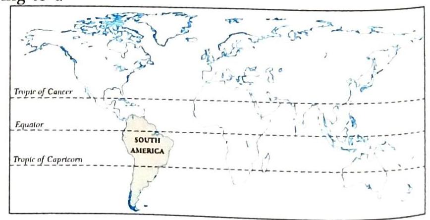
A Location of South America
A Location of South America

Mt Aconcagua
Mt Aconcagua