Chapter: 08. North America
THEME 6: STUDY OF CONTINENTS-NORTH AND SOUTH AMERICA
North America
Introduction to North America
Named after Italian explorer Amerigo Vespucci, who reached it in 1507 CE. Christopher Columbus, a 15th-century seaman, is traditionally considered to have discovered it in 1492 CE while seeking a new sea route to India. Adventurous European seamen like the Norsemen and Vikings had visited as early as 986 CE, but their visits remained forgotten. North America, along with South America, is referred to as the “New World”. This term is used because these continents were “discovered” by Europeans as recently as the 15th century CE.
Location of North America
Hemispheres: Lies in the northern and western hemispheres. Shape: Appears somewhat triangular. South: Joined to South America by the Isthmus of Panama (narrow stretch of land). North-west: Bering Strait separates Asia from North America. Latitudinal extent: 7° N latitude up to 84° N latitude. Longitudinal extent: 20° W longitude up to 179° W longitude. Important Latitudes/Longitudes: 49° N latitude: Marks the boundary between Canada and the USA. 100° W longitude: Passes through the centre of North America, near Winnipeg.
Political Divisions
The United States of America These two countries occupy more than three-fourths of North America’s area. Both lie north of the Tropic of Cancer. Tropic of Cancer: Passes through Mexico, which is also a large country. Region south of the Tropic of Cancer where the continent becomes very narrow. Includes countries: Guatemala, Belize, Honduras, Nicaragua, Costa Rica, El Salvador, and Panama. Collective name for the tropical islands of the Caribbean Sea. Includes: Cuba, Jamaica, the Dominican Republic, Haiti, Puerto Rico, and others. Baffin Island, Victoria Island, Ellesmere Island – large and often snow-covered. Greenland: Geographically part of North America but belongs to Denmark. It is the largest island in the world. Newfoundland: Large island off the north-east coast, important for fishing. Aleutian Islands: Along the north-west coast, extend like a chain between Asia and North America. North America at a glance
Some important countries of North America
A Location of North America
A Political map of North America
Physical Features
North America has four major physical divisions:
The Canadian or Laurentian Shield The Western Mountain System or Western Cordilleras The Eastern Highlands or Appalachian Mountains The Central Lowlands or Great Central Plains The Canadian or Laurentian Shield
Location: Stretches from the Hudson Bay southwards to the Great Lakes. Composition: Composed of some of the oldest known hard rocks. Mineral Richness: Rich in minerals like gold, silver, uranium, iron, nickel, and copper. Appearance: Semi-circular, with rocky hills several hundred metres in height. Worn down by ice sheets and glaciers over many thousands of years. Resulted in lowering of height to an average of 300-400 m above sea level. Surface has many deep hollows or depressions. Depressions formed when rocks were scraped and scoured by moving ice during the Ice Age. After the Ice Age, meltwater filled these depressions, forming many freshwater lakes. The five Great Lakes: Lake Huron, Lake Ontario, Lake Michigan, Lake Erie, and Lake Superior.
Δ Physical Map of North America
The Western Mountain System or Western Cordilleras
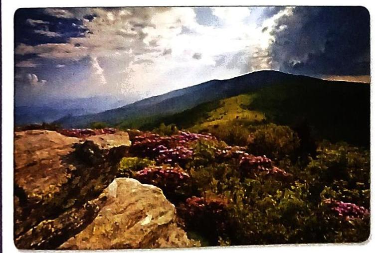
Stretches along the western part of North America. Extends from Alaska in the north to the Isthmus of Panama in the south. Forms a series of young fold mountain ranges. Extends for about 6,500 km in North America and continues as the Andes in South America. A Spanish word meaning “a rope or chain.” Named by Spanish explorers due to their resemblance to twisted cords. Refers to parallel ranges: Alaska Range, Coast Range, Sierra Nevada, Cascades, and the Rockies. Like the Himalayas (India) and Alps (Europe), they have steep slopes and high peaks. Region of active and extinct volcanoes and hot springs. Forms part of the Pacific Ring of Fire (due to proximity to Pacific Coast). Ranges, Plateaux, and Basins: Several parallel ranges with plateaux and basins between them. Alaska: Alaska Range and Brooks Range, with the Alaska Plateau in between. Pacific Coast: Coast Range, Cascades, Sierra Nevada, and Sierra Madre. Highest Point: Mt McKinley (now Mt Denali) in the Alaska Range. Renamed in 2015 to Mt Denali. “Denalee” means “the high one” or “the great one” in native Indian Koyukon language. Easternmost Range: The Rockies (highest part of the Cordilleras). Intermontane Plateaux and Basins: Located between the Pacific Coast ranges and the Rockies. Examples: Columbian Plateau, Colorado Plateau, Great Basin. Extensive river network has carved deep valleys. Deep valleys with almost vertical sides. A gorge is often smaller, steeper, and narrower than a canyon. The Grand Canyon of the Colorado River: World-famous for beauty and majesty, about 2,000-m-deep and 480-km long. Quick Facts
Ice Ages: Several Ice Ages in the past drastically changed Earth’s surface. North America’s Ice Age: Thick ice sheets covered mountains and hills, creeping southward. Melting Ice: Ice sheets began to melt and disappear, but not entirely. Greenland Today: Most of Greenland is still covered with an ice cap thousands of metres thick. The Eastern Highlands or Appalachian Mountains
Comparison: Lower than the Western Cordilleras. Height: Average height of 1,200-1,500 m. Parallel to the eastern margin of the continent. From Newfoundland in the north to Alabama-Georgia in the south. Highest Point: Mt Mitchell (2,037 m). Once higher than the Rockies. Eroded over millions of years by glaciers and rivers. Eastern Slopes: Steep, facing the Atlantic Ocean. Rivers rising in these highlands flow across this plateau. Located at the foot of the highlands. Rivers descend from the Piedmont Plateau to the eastern coastal plains in a series of waterfalls. The edge of this plateau, with many waterfalls, is called the Fall Line. Waterfalls utilized for hydroelectric power generation. Rivers used for transportation. Appalachians are rich in minerals. The Central Lowlands or Great Central Plains
Extends from the Hudson Bay in the north to the Gulf of Mexico in the south. Distance: More than 6,000 km. Lies between the Western Cordilleras and the Eastern Highlands. Slopes northwards in Canada: Drained by the Mackenzie River into the Arctic Ocean. Slopes southwards in the United States: Drained by the Mississippi-Missouri rivers into the Gulf of Mexico. River System: The Mississippi-Missouri rivers form the largest river system in North America.
Sustainable Development Goals (SDGs) - Goal 16: Peace, Justice and Strong Institution
USA as a “Melting Pot”: Home to diverse groups and cultures (e.g., from China, India, Brazil, Australia) for education and employment. Historical Challenges: Nation has faced strained interactions between cultural groups.  Self Study

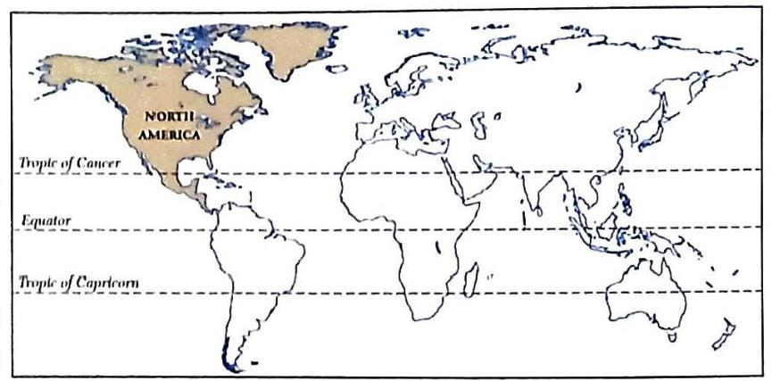
A Location of North America
A Location of North America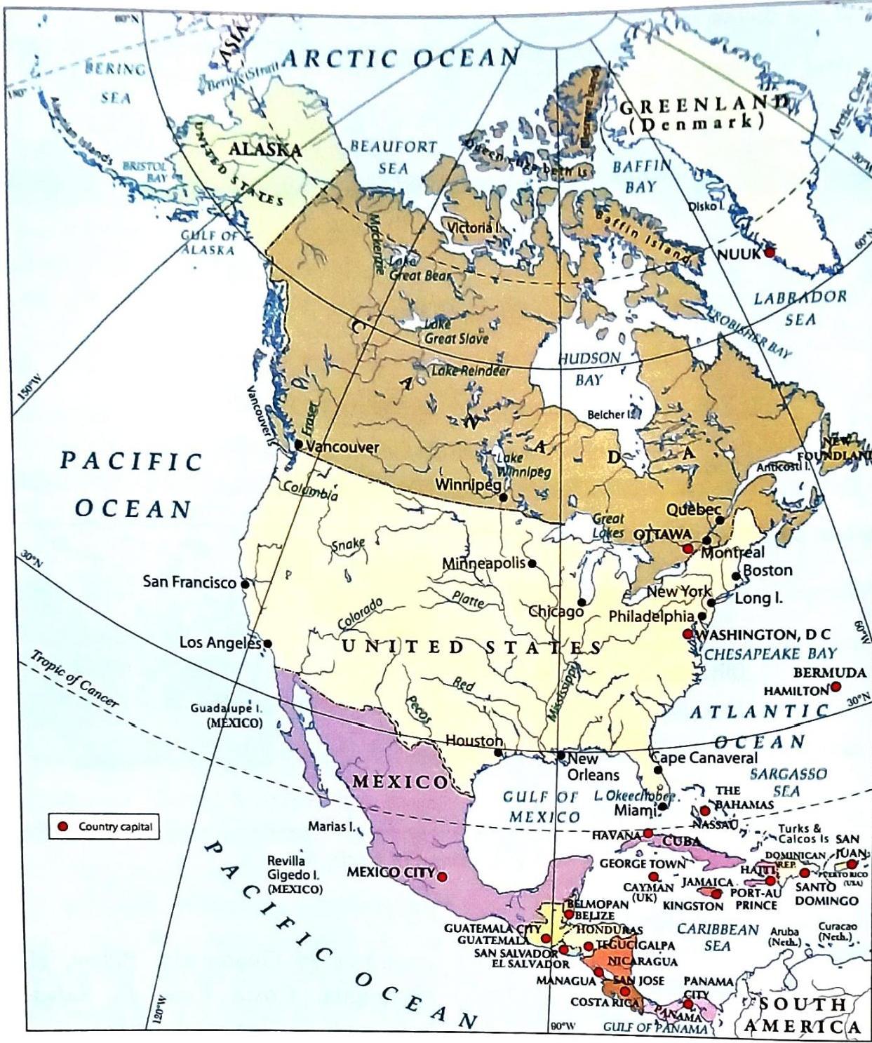
A Political map of North America
A Political map of North America

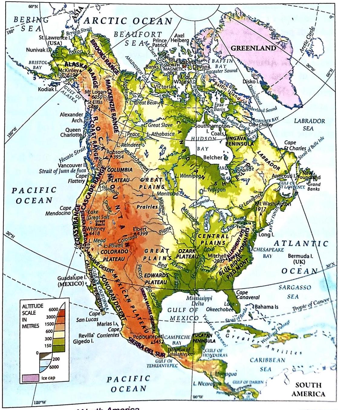
Δ Physical Map of North America
Δ Physical Map of North America

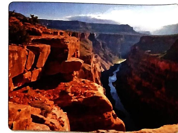
Δ The Grand Canyon
Δ The Grand Canyon