Chapter: 02. Elements Of A Map
THEME 1: REPRESENTATION OF GEOGRAPHICAL FEATURES
Elements of a Map
Learning Outcomes
After studying this chapter, you will be able to:
List the basic elements that make up a map. Identify different directions, including the four cardinal directions and the eight cardinal points. Understand how scales and symbols are used for measurements and representation on a map. ELEMENTS OF A MAP
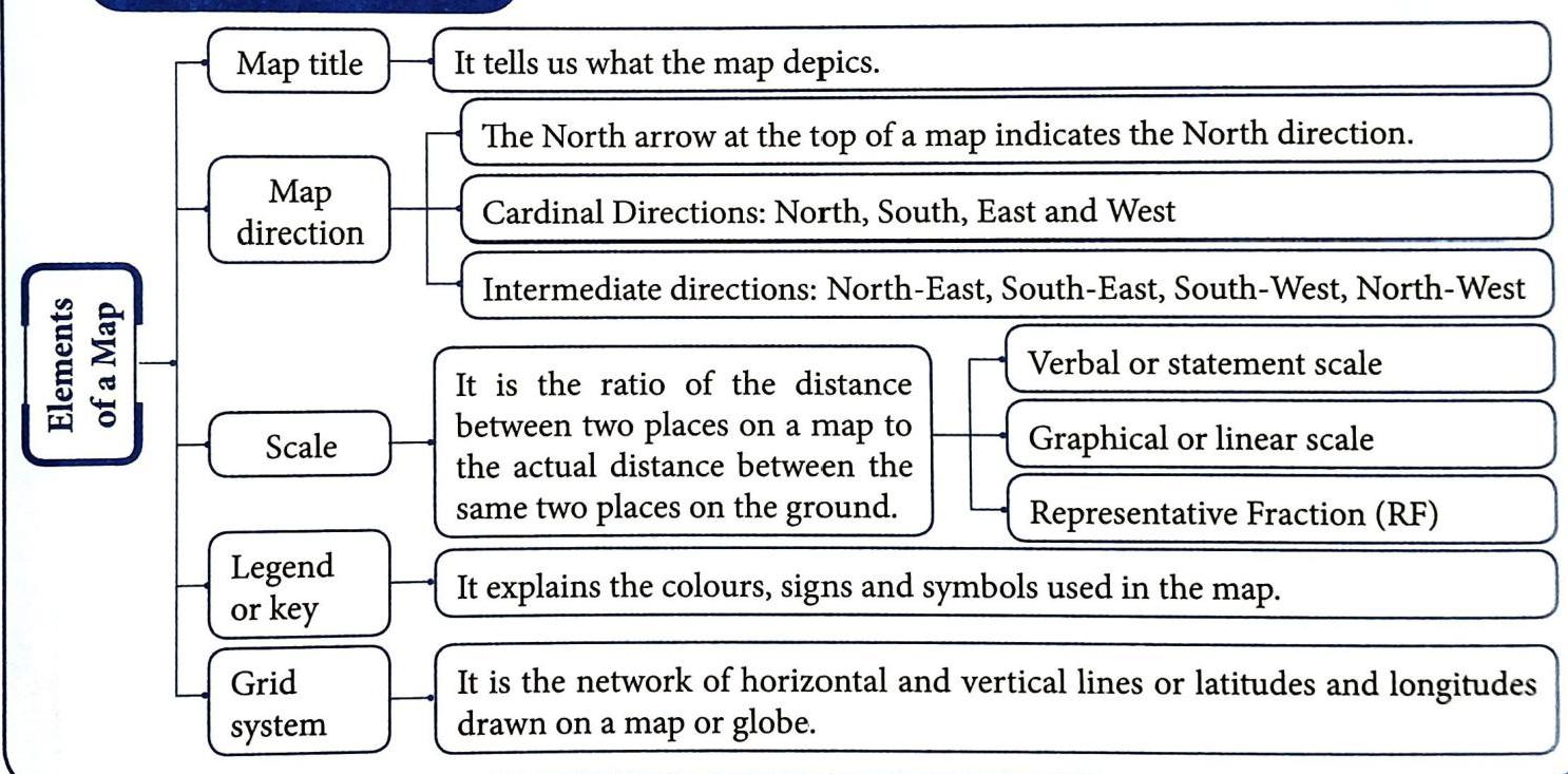
Maps help us understand the world around us. They use special elements to communicate information clearly. There are five basic elements that every map has:
Map Title
The map title clearly states what the map is about.
It tells you the subject or topic of the map. For example, a map titled “INDIA POLITICAL” will show the political divisions of India (like states and their capitals). The title is usually written very clearly at the top of the map.
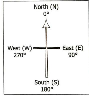
Map Direction
Understanding direction is key to reading a map.
North Arrow: On a map or plan, a symbol like ↑ at the top usually indicates the North direction. Default Direction: If no such symbol is shown, you can assume that: The top portion of the map is North. Cardinal Directions
The four main directions (North, South, East, and West) are called the cardinal directions. They are the fundamental points used for orientation.
Did You Know?
A magnetic compass is a tool used to find directions on the ground. It has a floating needle that always points towards the North.
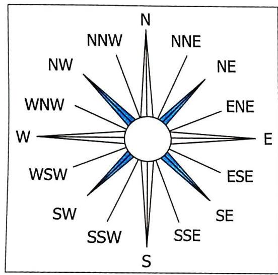
Intermediate Directions
The four cardinal directions can be further divided into intermediate directions for better accuracy. These are the directions that lie between the cardinal points: North-East (NE): Between North and East South-East (SE): Between South and East South-West (SW): Between South and West North-West (NW): Between North and West Eight Subdivisions (for greater accuracy)
For even greater accuracy, these four intermediate directions can be further divided to get eight additional directions, making a total of sixteen points on a compass rose. This means places lying halfway between North and North-East would be in the North-North-East direction.
Map Scale
A map scale is very important because it tells you the relationship between distances on the map and actual distances on the ground.
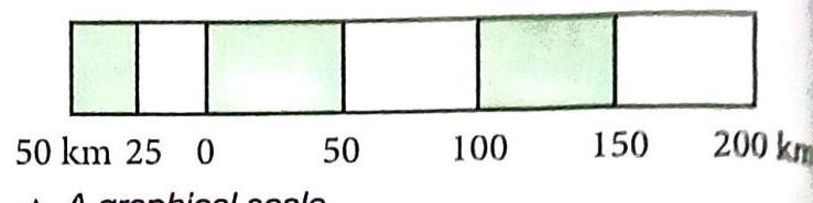
Definition: It is the ratio of the distance between two places on a map to the actual distance between the same two places on the ground. Map scales are shown in three different ways: Verbal or Statement Scale: This scale is stated in words. The units (like centimeters and kilometers) are usually mentioned. Example: “1 cm = 5 km” or “1 cm to 5 km”. This means that 1 centimeter on the map represents an actual distance of 5 kilometers on the ground. Graphical or Linear Scale: This scale is a straight line divided into segments. Each segment represents a specific distance on the Earth’s surface. It is usually drawn near the lower part of the map.
Representative Fraction (RF): This is a fraction where the top number (numerator) shows the distance on the map. The bottom number (denominator) shows the actual distance on the ground. The numerator is always 1. Both the numerator and the denominator must be expressed in the same unit. Formula: RF= Distance on the map / Distance on the ground Example: 1/50,000 or 1: 50,000. This means that 1 cm on the map represents 50,000 cm on the ground. (Since 50,000 cm = 0.5 km, this is a common way to express it).
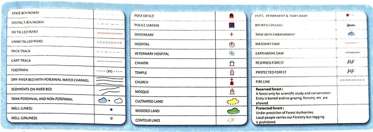
Legend or Key
The legend, also known as the key, is like a dictionary for your map.
Purpose: It is an essential feature that explains the meaning of all the colours, signs, and symbols used in the map. Colours for Height/Depth: It often uses different colours to show the height of an area above sea level or its depth below sea level. Location: The legend is usually found near the top or the bottom of the map, either on the left or right side.
Conventional signs and symbols
Maps use a variety of signs and symbols to represent real-world features.
Purpose: These colourful signs and symbols are used to show both natural features (like rivers and mountains) and man-made features (like roads and buildings). They provide a lot of information in a small space. They are simple to draw and easy to understand. International Recognition: Many of these symbols are “conventional,” meaning they have been agreed upon and accepted by people and countries all over the world. This international agreement makes them easily understandable to anyone familiar with mapping conventions, regardless of their language or country. Therefore, a person familiar with these symbols can easily interpret maps from other countries.
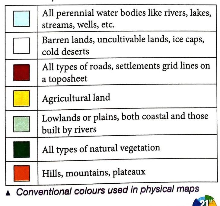
Colours in maps
Colours are not just for making maps look pretty; they play a very important role in helping us understand maps quickly.
Role: Colours make maps attractive, easy to understand, and simple to interpret. Conventional Use on Physical Maps: On maps that show physical features (like landforms and water bodies), different colours are used in a standard, agreed-upon way: Light Blue: Used for perennial water bodies (water bodies that exist all year round), such as oceans, seas, lakes, and rivers. White: Used for barren lands (land that is too dry or infertile to grow plants). Dark Red: Used for roads and settlements (areas where people live, like towns and cities). Yellow: Used for agricultural land (land used for farming). Light Green: Used for lowlands or plains (flat areas of land that are not very high above sea level). Dark Green: Used for natural vegetation (forests, grasslands, and other areas with natural plant cover). Orange: Used for hills, mountains, and plateaux (highlands).
Grid System
The grid system is a network of imaginary lines drawn on maps and globes. These lines help us locate places accurately.
Definition: It is a network of horizontal (east-west) and vertical (north-south) lines, also known as latitudes and longitudes, drawn on a map or globe. Latitudes (Horizontal Lines)
Direction: These are horizontal lines that run from east to west. The longest latitude is the Equator, at 0°. It is a Great Circle, meaning it divides the Earth into two equal halves or hemispheres. The northern half is called the Northern Hemisphere. The southern half is called the Southern Hemisphere. Parallelism: All other latitudes are parallel to the Equator. Length: Their length decreases as you move towards the poles. At the poles, they are just points. Numerical Value: The numerical value of a latitude is followed by the letter ‘N’ for North or ‘S’ for South of the Equator (e.g., 30° N, 45° S). Other Important Lines of Latitude: The Tropic of Cancer: Located at 23 ½° N (north of the Equator). This is the northernmost point where the sun’s direct rays are received. The Tropic of Capricorn: Located at 23 ½° S (south of the Equator). This is the southernmost point where the sun’s direct rays are received. The Arctic Circle: Located at 66 ½° N (north of the Tropic of Cancer). The Antarctic Circle: Located at 66 ½° S (south of the Tropic of Capricorn). The North Pole: Is at 90° N latitude (a point). The South Pole: Is at 90° S latitude (a point). Longitudes (Vertical Lines)
Direction: These are vertical lines that run from north to south, from pole to pole. Length: All longitudes are semicircles and are of the same length. Circles: Two opposite longitudes form a complete circle. The 0° longitude is called the Prime Meridian. It passes through a place called Greenwich, near London, which is why it’s also known as the Greenwich Meridian. The Prime Meridian and its opposite, the 180° longitude (International Date Line), form a circle that divides the Earth into two halves: The Prime Meridian helps to determine time worldwide. Numerical Value: The numerical value of a longitude is followed by the letter ‘E’ for East or ‘W’ for West of the Prime Meridian (e.g., 15° E, 120° W). International Date Line (180°): This is the 180° meridian. You do not write ‘E’ or ‘W’ with 180° because 180° E and 180° W are the same line. It helps to determine the day and date. When you cross this line, the day and date change because there is a 24-hour (one day) time difference between its two sides. Importance of the Grid System
The grid system is a crucial feature of maps. It helps in accurately locating any place on the surface of the Earth. To locate a place, you would look for the point where its specific latitude and longitude lines intersect. Knowing the latitudes and longitudes of important towns and cities allows you to find them on a map.
Difference between latitudes and longitudes
Values and Life Skills
Being able to use a compass and understand directions is a very valuable skill. It helps us navigate and also allows us to help others who might be lost or seeking directions. It’s good to always be able to give correct directions to people who ask for help.
Biography
Gerardus Mercator (1512-1594)
Nationality: He was a Belgian cartographer (a person who makes maps). First World Map: In 1538, he created his very first world map. Coining the Term ‘Atlas’: He is famous for coining the term ‘atlas’ to describe a collection of maps. First Globe: In 1541, Mercator published his first globe, which was very popular and sold in large quantities for decades.
Points to Remember
Here’s a quick recap of the most important things from this chapter:
Elements of a Map: There are five main elements: Map Title, Map Direction, Scale, Legend or Key, and Grid System. Map Title: Tells you what the map is about. Includes the North arrow for orientation. Cardinal Directions: North, South, East, West. Intermediate Directions: North-East, South-East, South-West, North-West. Scale: The ratio of distance on the map to the actual distance on the ground. Types include: Verbal or statement scale, Graphical or linear scale, and Representative Fraction (RF). Legend or Key: Explains the colours, signs, and symbols used on the map. Grid System: The network of horizontal and vertical lines (latitudes and longitudes) that helps locate places.
Important Terms
Understanding these terms will help you understand maps better.
Cardinal directions: The four main directions: North, South, East, and West. Scale: The ratio that compares the distance between two places on a map to the actual distance between those same two places on the ground. Legend: An essential part of a map that explains the meaning of the colours and symbols used on the map. It is also called a Key. Conventional signs and symbols: Signs and symbols that are recognized and accepted internationally to show natural and man-made features on maps. Grid system: The network of latitudes (horizontal lines) and longitudes (vertical lines) drawn on a map or globe.
 Self Study