Chapter: 01. Maps And Diagrams
I. Multiple Choice Questions (5 Marks)
Choose the correct option for each question.
Which of these is the most accurate three-dimensional representation of the Earth?
(a) Map
(b) Sketch
© Globe
(d) Plan A collection of different types of maps bound together in a book is called an:
(a) Dictionary
(b) Atlas
© Encyclopedia
(d) Journal Which type of map would you use to find the boundaries of countries and their capital cities?
(a) Physical map
(b) Thematic map
© Political map
(d) Topographical map If 1 cm on a map represents 200 km on the ground, what type of map is it?
(a) Large-scale map
(b) Small-scale map
© Physical map
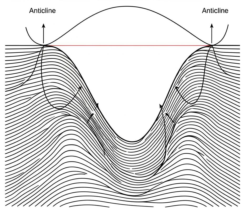
(d) Thematic map The upward arch of a fold in the Earth’s crust is known as a(n):
(a) Syncline
(b) Fault
© Anticline
(d) Meander II. Fill in the Blanks (5 Marks)
Complete the sentences with the correct word(s).
A _ _ _ _ _ _ _ _ _ _ _ _ _ _ is a drawing that shows the horizontal section of a small area or a building, drawn to scale. The art of drawing or making maps is called _ _ _ _ _ _ _ _ _ _ _ _ _ _. A _ _ _ _ _ _ _ _ _ _ _ _ _ _ is a loop-like bend in a river. When a river splits into a separate channel that does not rejoin the main river, it forms a _ _ _ _ _ _ _ _ _ _ _ _ _ _. _ _ _ _ _ _ _ _ _ _ _ _ _ _ maps provide detailed information about local landforms and structures, useful for civil engineers. III. True/False Questions (4 Marks)
State whether each statement is True or False.
Maps are generally difficult to carry around compared to globes. A sketch is always drawn to scale and shows true shapes and sizes. Physical maps generally use different colors to represent land of different heights. Block mountains are formed when the land between cracks in the Earth’s crust sinks. IV. Explanations of Terms (3 Marks)
Define the following terms in one sentence each.
V. Short Answer Questions (6 Marks)
Answer the following questions briefly.
List two reasons why maps are important. What is the main difference between a sketch and a plan? Name two features that physical maps typically show. VI. Diagram-Based Question (3 Marks)
Observe the image description and answer the questions.
This image shows a geological cross-section with folded rock layers. What causes the Earth’s crust to form these folds? What is the name for the downward-dipping part of a fold? VII. Long Answer Question (4 Marks)
Answer the following question in 4-5 sentences.
Imagine you are a town planner. Explain how large-scale maps would be essential for your work, compared to small-scale maps.  Question Paper