Chapter: 09. South America
A. Choose the correct option.
The _ _ _ _ _ _ _ _ _ _ _ _ _ _ _ _ _ _ _ longitude passes almost through the middle of this continent.
(i) 60° W
(ii) 30° W
(iii) 45° W
(iv) 50° W Brazil and _ _ _ _ _ _ _ _ _ _ _ _ _ _ _ _ _ _ _ are the two largest countries of South America.
(i) Colombia
(ii) Peru
(iii) Bolivia
(iv) Argentina The _ _ _ _ _ _ _ _ _ _ _ _ _ _ _ _ _ _ _ islands are an archipelago of volcanic islands.
(i) Galápagos
(ii) Falkland islands
(iii) South Sandwich islands
(iv) Selvas Mt Chimborazo, Mt Cotopaxi and Mt Cayambe are all _ _ _ _ _ _ _ _ _ _ _ _ _ _ _ _ _ _ _ volcanoes.
(i) dormant
(ii) active
(iii) extinct
(iv) very active The Gran Chaco is a vast _ _ _ _ _ _ _ _ _ _ _ _ _ _ _ _ _ _ _ region.
(i) alluvial
(ii) desert
(iii) volcanic
(iv) sub-merged B. Identify who I am.
I am a narrow neck of land that joins South America to North America and separates the Atlantic Ocean from the Pacific Ocean: . I am a hot desert that lies in the western coastal region of South America and stretches across the Tropic of Capricorn: . I am one of the few gaps in the Andean Mountain chain: . I am the highest peak of the second highest young fold mountain chain of the world, with a height of 6,960 metres above sea level: . I am the second highest freshwater lake in the world: . C. Match the following.
Argentina - (iii) Buenos Aires Uruguay - (ii) Montevideo D. State whether the following are true or false. Rewrite the false statements correctly.
The 60° W longitude passes almost through the middle of South America. The Orinoco Plains are called the llanos. The selvas are another name for the grasslands of Argentina. False. The selvas are the dense equatorial forests of the Amazon Basin. The La Plata river system drains southwards into the Atlantic Ocean. Lake Titicaca and Lake Poopo are saltwater lakes. False. Lake Titicaca is a freshwater lake, while Lake Poopo is a saltwater lake. E. Explain the differences between each of the following pairs.
Pampas are extensive temperate grasslands found in Argentina, Uruguay, and parts of Brazil, known for cattle grazing, dairying, and wheat cultivation. Prairies are temperate grasslands found predominantly in North America (e.g., central USA and Canada), characterized by fertile soil and used for grain farming and cattle ranching. Life of lumberjacks of Canada and the life in the Amazon Basin Life of lumberjacks in Canada involves working in cold, often snow-covered coniferous forests, cutting down softwood trees for timber and wood pulp, typically in remote camps and often seasonally. Life in the Amazon Basin involves indigenous people living in hot, wet, and humid equatorial rainforests, relying on the forest for subsistence through hunting, fishing, gathering, and growing crops; travel is primarily by boat, and their traditional lifestyle faces threats from external activities like logging. Answer the following questions in brief.
Name any two physical divisions of South America. The West Coastal Plains, The Andes Mountains. Name the water bodies that lie to the east and the west of this continent. East: Atlantic Ocean; West: Pacific Ocean. Name any two tributaries of the Amazon River. The chapter states that the Amazon River has a number of tributaries but does not list specific names. In what respect is the Atacama Desert different from the Patagonian Desert? The Atacama Desert is a hot desert located in northern Chile and is known as the driest desert in the world, receiving little to no rainfall due to being in the Andes’ rain shadow and influenced by the cold Peru Current. The Patagonian Desert is a cold desert located in southeastern Argentina, which also lies in the rain shadow of the Andes but experiences cool temperatures throughout the year. Name three Andean towns that are also capital cities in South America. La Paz (Bolivia), Quito (Ecuador), Bogota (Colombia). Answer the following questions.
Differentiate between the following: llanos, selvas and pampas Llanos: These are the tropical grasslands found in the Orinoco Basin in the northern part of South America’s Central Plains. Selvas: These are the dense equatorial rainforests found in the Amazon Basin, characterized by high temperatures, heavy rainfall, and immense biodiversity. Pampas: These are the extensive temperate grasslands located in Argentina, Uruguay, and parts of Brazil, known for their fertile soil and suitability for cattle grazing and wheat cultivation. Give reason: The Gran Chaco becomes a marshy region in the rainy season. The Gran Chaco becomes a marshy region during the rainy season because it is a vast alluvial plain that is not well-drained. Its flat topography and the nature of its soil allow water to accumulate rather than drain away effectively, leading to waterlogging. How are the Eastern Highlands different from the Andes Mountains? The Eastern Highlands (Guiana and Brazilian Highlands) are composed of old, hard crystalline rocks, are much lower in height compared to the Andes, and rise steeply from the Atlantic coast before gently sloping towards the Central Plains. In contrast, the Andes Mountains are high, young fold mountains formed by tectonic plate movements, running parallel to the Pacific Coast, and are the second highest and longest mountain range in the world with numerous lofty peaks and active volcanoes. Give three features of the Amazon, the largest river of South America. The Amazon River is the second longest river in the world, after the Nile. It carries the largest volume of water in the world, fed by thousands of tributaries and daily heavy equatorial showers. It is navigable by ocean-going liners up to Manaus, allowing large ships to travel deep into the continent. Describe the La Plata river system. The La Plata river system is formed by the confluence of three major rivers: the Parana, Paraguay, and Uruguay rivers. These rivers flow southwards across the continent and drain into the South Atlantic Ocean through a wide estuary known as Rio De la Plata, which also serves as an excellent natural harbor in Argentina. H. Map work
This section requires physical map marking, which cannot be provided in text format. I. Source-based questions
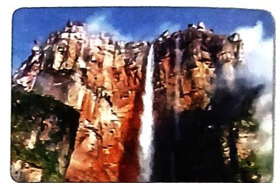
Which river forms this waterfall? A tributary of the Orinoco River  Answers to textbook exercises